2. Earth
shadow during a lunar eclipse and sickle moon is
ROUND 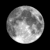

During a lunar eclipse the Earth's shadow is covering
the moon step by step, and this Earth's shadow is ROUND
[web02]:

Lunar eclipse in Europe of September 28, 2015 [2]
Even Aristoteles saw that the Earth's shadow on the moon is
ROUND during a lunar eclipse [web03].
"Moon sickles" are sickles because the Earth's shadow is
ROUND...  [3]
[3]
========
3. Magellan's fleet completed
the tour aROUND the Earth 1519-1522 (1 of 5 ships)

[web04]
Since 1492 the criminal gay Pope had parted the world, in
1494 he parted the world definitively into a Portuguese and
a Spanish "half". So, the Magellan's fleet was first in the
"Portuguese" zone, then in the "Spanish" zone reaching the
Philippines, and from the Molucca Islands on it was again in
the "Portuguese" zone heading home around Africa.

Map with the Tordesillas Line of 1494 and with the Zaragoza
Line from 1529 [4]
The tour around the world from Magellan - accidents,
stress and losses


The map with the tour around the world by the Magellan's
fleet 1519-1522 [5] - Magellan, portrait [6]
Reaching Brasil all was normal. But then the problems came:
The expedition was looking for a passage passing today's
Argentina controlling all the big bays loosing about 1 year
alone with this (!). The big bays were always dead ends.
Additionally winter was forcing the expedition halting
during months. One ship was crashing in a storm. During a
rebellion one group of seamen returned with the food ship
and could escape. Three ships reached the Philippines
Islands where Magellan was given the task to calm down a
quarrel but was killed. With further quarrels between
sultans on the Philippines a part of the expedition was
killed so it was only possible to go on with 2 ships. The
boss now was Cano (Juan Sebastian del Cano). When the
expedition reached the Molucca Islands another ship was
lost, may be by leakage or because it was robbed by
Portuguese forces. Return was managed by only one single
ship taking a cargo of spices from the Moluccas to Europe.
Map material and protocols were saved. Details: https://en.wikipedia.org/wiki/Ferdinand_Magellan
Thus: Earth is ROUND.
One more tour around the world by Francis Drake 1577-1580
From 1570 to 1577 the sea criminal and pirate Francis Drake
was robbing many Spanish towns and ships. The tour around
the world from 1577 to 1580 was only the "climax" of his
criminal career marking also an "English" tour around the
world in the world wide history books. His "hobby" during
this tour was robbing and sacking of Spanish coast towns in
today's Chile and Peru. At the end he was ennobled by the
"English Queen" for his criminal sacking activities [web04].
 Francis Drake, portrait [7]
========
4. Pythagoras, Platon and Aristoteles knew that
Earth is a ball / a globe 
Teaching doctrine in the upper
classes was almost EVER that Earth is a ball or a
globe. Only in the analphabetic popular classes
there was always the rumor spread with the fake that
Earth would be a disc, with the justification
-- that continents would be only islands in the sea
-- that in former epos of Homer Earth was also
descripted as a disc in the water with a sky as a
hemisphere [web05].
But world view as a disc changed soon: Pythagoras,
Platon and his pupil Aristoteles knew that Earth is
a ball resp. a globe
-- they meant yet that Earth is the center of
Universe so all was turning around the Earth thus
Earth had to be a ball or a globe
-- zodiacs of the Northern hemisphere were others
than in the Southern hemisphere
-- the shadow of the earth during a lunar eclipse is
round [web05].
========
5. Astronomers calculated the
Earth's circumference before more than 2,000 years
already 
First Eratosthenes calculated the Earth's
circumference: 7 degrees aberration of sun's position
during midday between Alexandria and Syene (today's
Assuan)
Eratosthenes is said having calculated the Earth's
circumference first in the late third century BC. He knew that
the distance between Alexandria and Syene (today's Assuan) is
about 5000 stadiums (stadia, 1 stadium is 148.5m). During
summer solstice he controlled the sun's position during
midday: the sun was in a right angle over Syene, and in
Alexandria there was a 7 degree inclination. So this
aberration of 7 degrees was the key for his calculation. In a
normal circle of 360 degrees 7 degrees are about 1/50 of a
circle. Thus he only had to multiply the distance between
Alexandria and Syene by 50 for getting the Earth's
circumference: 50 x 56,000 stadia = 250,000 stadia. This
calculation was coming near to the Earth's circumference
[web05].
 ")
Eratosthenes, profile [11] - scheme of Eratosthenes
with 7 degree's aberration between Alexandria and
Syene (today's Assuan) 01 [12]
|
When in Syene (today Assuan) during summer solstice the sun is
in a right angle during midday then the sun's position in
Alexandria is about 7 degrees inclined.
 02")
Scheme of Eratosthenes with 7 degrees aberration
between Alexandria and Syene (today's Assuan) 02
[13]
|
7 degrees are about 1/50 of a circle of 360º (calculated
precisely: 360:7=51.43).
Thus the Earth's circumference is about 50 times the distance
between Alexandria and Syene (today's Assuan): 5,000 times a
stadium ()148.5m)=742.5km.
The calculation of Eratosthenes: 50 x 742.5km = 37,125km.
Assuming that Eratosthenes could calculate precisely so he
also calculated precisely:
51.43 x 742.5km = 38,186.775km
With the geographic satellite measurements of the areal
distance between Alexandria and Syene 845.27km come out for
this air trip [web06]. Thus the precise calculation is: 51.43
x 845.27km=43,472.24km.

Map with the satellite distance between Alexandria and
Assuan: 845.27km [14]
Today's equator's circumference being measured by satellites
is 40,007.76km [web05].
Flattened Earth
Now one has to consider also the following fact: Earth is not
a precise ball or globe but is flattened on the poles. There
is a medium Earth's radius, and at the poles the Earth's
radius is minus 14km, and on the equator it's +7km. Thus the
total difference is 21km (!), so the diameter of the Earth is
varying 42km (!) [web07],

Earth is not a ball but a flattened globe, an oval
[15]
|
Thus the circumference on a line of longitude is shorter
than the circumference of the equator, and Eratosthenes was
just very near at the truth with the calculation of
38,186.775km of the Earth's circumference at a line of
longitude.
Ptolemy with Earth in form of a ball in a geocentric
vision of the world
In the second century AC Ptolemy composed the first globe
model. He thought yet that the Earth would be the center of
the universe. He invented the terms of "line of longitude"
and "line of latitude". He calculated an Earth's
circumference of 30,000km [web05].

 im Mittelpunkt")
Ptolemy with a right angle [16] - Geocentric vision of the
world by Ptolemy with the Earth (Terra) in the middle [17]
Galileo Galilei and heliocentric vision of the world
Helios is a Greek word and means "sun". Heliocentric
means that the sun is in the middle. Galileo Galilei was
one of the scientists stating clearly that the world was
ordered with the Earth which was turning around the sun
and not the other way round [web07].


Galileo Galilei, portrait [18] - Heliocentric vision of the
world with the sun in the center [19]
But the criminal gay satanist drug club "Vatican" did
not want to accept that the astronomers would find out
that the sun is in the middle of the solar system and
Earth would turn around the sun. Criminal gay and drug
addicted Vatican was pursuing hundreds of scientists,
among others Galileo Galilei. He made some jokes in his
book "Dialogue" (Dialogo sopra i due massimi
sistemi) against the
gay and corrupt Pope so he had to stay under arrest for
years, he was forced to "abjure" from the heliocentric
vision of the world, and his daughter Suor Celeste took
over the obligation to pray 7 "punishing Psalters" all
weeks during over 3 years [web07].
In Latin
"America" the situation did not change much: Catholic
population is against scientists but is following the
stupid pastors yet and does NOT see until today that the
pastors are COLONIALISTS and that the Bible is from ASIA
and is 2,000 years old and nothing is true in this
Jewish war fantasy. The error Catholics partly believe
until today (2017) only what is in the Bible and the
DON'T READ ANY OTHER BOOK but only want to hear the
pastor and the religious radio. Thus there is the normal
poverty and also the spiritual poverty with these
criminal corrupt Catholics.
========
6. World maps: first there were discs - then
there were rectangles - then Mercator projection
came with nets and longitude and latitude in 1569 -
at the end the maps are ovals

The old maps BEFORE Mercator's projection show an Earth
and it's continents as a "disk" because in those times it
was not known how to draw a ball on a flat paper.
Additionally "America" was unknown first - officially. The
high political lodges were well informed about the truth
of the continents of Earth, they knew that "America"
exists. The flat Earth discs had different "centers": one
time it was Cairo and Giza, another time it was Jerusalem,
another time it was Mecca or a "Paradise".
When "America" was officially unknown yet it was simple to
draw the flat Earth as a "disc":


Flat earth disc 6th century BC by Hekataios of Milet -
center is Milet [map01] - Flat earth disc by Al Idrisi from
Arabia - center is Mecca, north is downwards [map02]
flat earth disc of criminal gay Vatican - center is
Jerusalem [map03]
Al Idrisi draw all in all an atlas with 71 maps [web08].
Criminal gay Vatican was propagating this flat earth disc for
about 750 years showing Jerusalem as his center of the world
[web08].


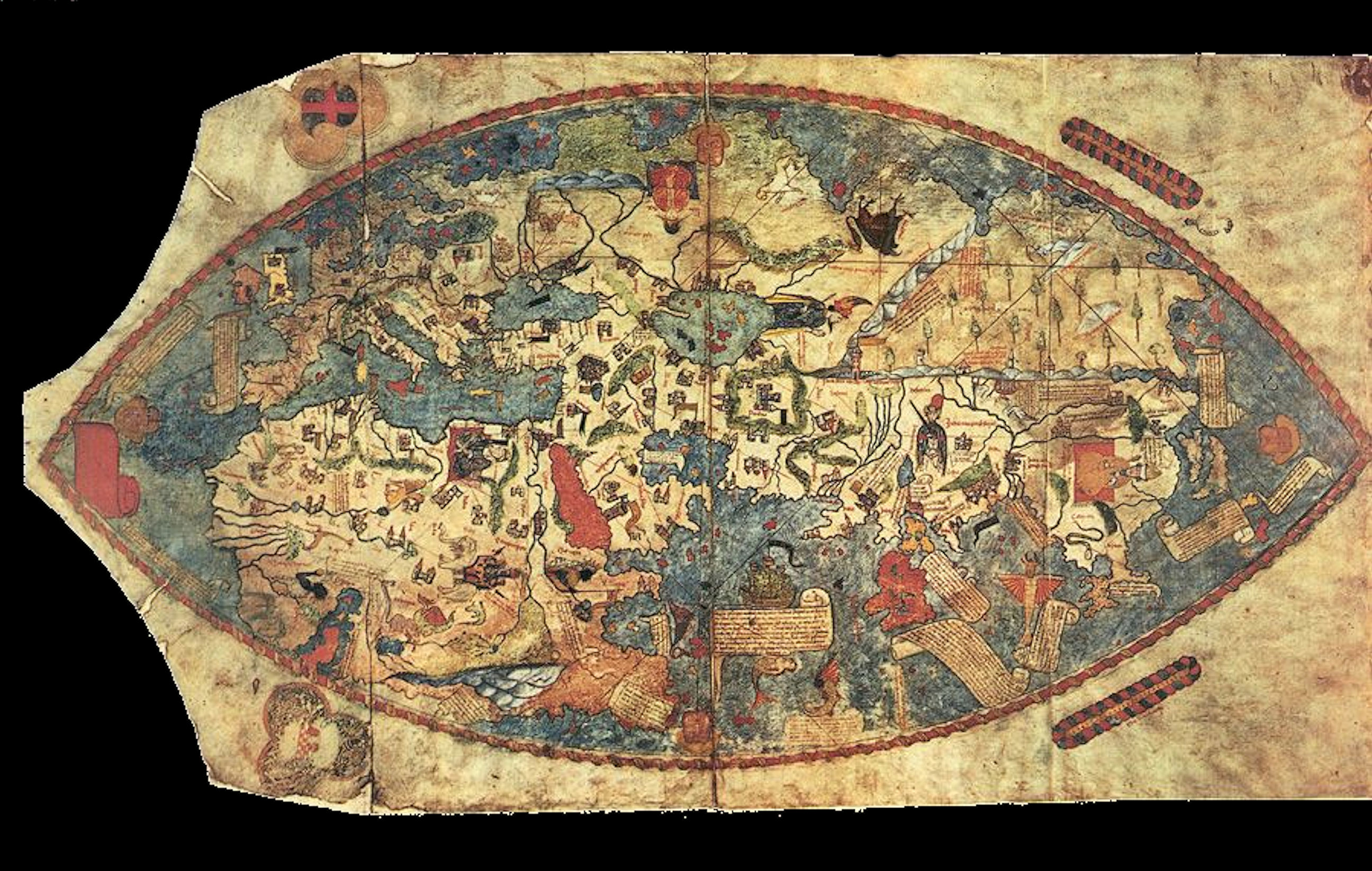
World map by Piri Reis from 1513, it's
part of a globe map with Egypt as it's center [map10-01] -
the map of Piri Reis shows the Atlantic with coast lines
of Africa and South "America" [map10-02] - and the whole
map is from a perspective from about 30km with the center
of Cairo - see the movie "Memories of the Future" from
Erich von Däniken [map10-03]
This map is made from about 30km of height with Cairo as
it's center. Thus this map has to be from
extraterrestrials because humans could not fly in these
heights, or extraterrestrials took somebody with them to
make a photo, or the map is made much later when humans
could fly so high. as a coincidence Cairo and Giza were
the center of Egypt pyramid culture where this map has
it's center more or less. Additionally Cairo is the center
of gravity of all continents. The pharaohs were
extraterrestrials and every obelisk is a symbol for a
little space ship for reaching the mother space ship. So,
the thesis that this map was made by extraterrestrials
does not sound rare.


World map by Franciscus
Monachus 1526 [map11] - World map by Sebastian Münster
1552: this is the first map showing "America" as an own
continent without connection to Asia [map12]
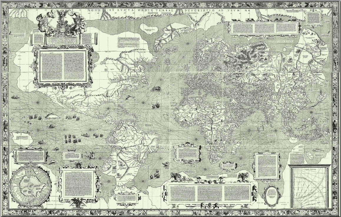
1569: Mercator projection and faked shapes
of Canada, Greenland, and Russia
Gerhard Mercator came from Flanders. His original name was
Gerard de Kremer, and his name was "latinized" to Gerardus
Mercator. With his maps he was a pioneer, and he was also
cosmographer and philosopher [web08]. Gerhard
Mercator produced a globe in 1541 [web10].

Mercator's globe from 1541
In 1569 he developed his
"Mercator
projection" for precise navigation purposes [web09].
Mercator cut the map of a globe - and then he put
interspaces at the top and at the bottom so there were
straight lines - and the landscape was "extended" there.

World map with Mercator projection 01, the working process
[map13-02]
In this way there is a rectangular map with the first
straight longitude lines and latitude lines so it was
possible the first time to define positions precisely. This
was a sensation in those times. At the same time the
distances at the top and at the bottom were "filled" so
bigger surfaces came out there. Territories were "extended",
so: Greenland, Canada, Russia and Antarctica were much too
big on this Mercator map or were not shown at all [web11]:

World map with Mercator projection 02 from 1569: This was
the first map with a net of lines making a precise
navigation possible, but northern and southern regions and
polar regions came out much too big [map13-03]
When this Mercator projection is applied more and more so
Canada is bigger than "USA", Russia is a giant, and
Greenland becomes as big as Africa. Therefore the politic
NWO Satanists in the Committee of 300 are always with "fear
from Russia" - because the map is WRONG. The reality is
another one:


World map with Mercator projection 03 with Greenland as big
as Africa [map13-04] - the reality about Africa and
Greenland is seen here on a globe [map13-05]
Therefore the best is a Mercator map without polar
regions, but one can show the polar regions separately with
the view from above:


 Mercator projection 04 completely [map14] -
Mercator projection 05 with cut poles [map16] - South Pole
with Antarctica, view from above [map15]
Mercator projection 04 completely [map14] -
Mercator projection 05 with cut poles [map16] - South Pole
with Antarctica, view from above [map15]
Bellied world maps with more real dimensions of the
continents
A bellied world map represents more the real dimensions but
Greenland and Antarctica are much too big yet:

World map from 1990 apr. with a bellied form is representing
more the real dimensions of continents [map16]
When one is forming the belied form to
an oval completing it at the top and at the bottom so the
dimensions become almost real - and suddenly Canada,
Russia and Greenland become much more little:

World map from 1990 apr. with a bellied form completed to an
oval with the almost real dimensions of the continents
[map17]
Destroying the Illusion on March 31, 2018:
Earth is ROUND - double forces, Ley energy lines and
energy points with anomalies are proofs for that
Also the channel "Destroying the Illusion" presents facts
that Earth is ROUND and all the discussion about a flat
Earth is only a DIVERSION:
see
the video: Examining "Flat Earth" - Why ROUND Matters
(17'20'')
https://www.youtube.com/watch?v=Hm1iTIa7rFk
 is spreading FAKE news about a flat Earth
for stupification and diversion of the masses")
Channel "Destroying the Illusion": NWO (Deep State) is
spreading FAKE news about a flat Earth for stupification and
diversion of the masses [20]
![The
channel "Destroying the Illusion" means that
the Ley lines and the energy centers forming a net
around all the globe would be the proof that Earth is
round [21] because on a flat Earth, all these Ley lines
and energy centers would not exist...](erde-ist-KUGEL-d/021-Destroying-the-Illusion-Ley-Linien+energiezentren-netz-auf-ganzer-erde.jpg "The channel \"Destroying the Illusion\"
means that the Ley lines and the energy centers forming
a net around all the globe would be the proof that Earth
is round [21] because on a flat Earth, all these Ley
lines and energy centers would not exist...")
The channel "Destroying the Illusion" means that the Ley
lines and the energy centers forming a net around all the
globe would be the proof that Earth is round [21]
because on a flat Earth, all these Ley lines and energy
centers would not exist...
Video minutes:
The NWO propagandists have put the theory of a flat earth
into the world to distract from certain things that need to
be hidden. Earth is not only round, but it also rotates, and
this is all to be concealed - so, the theory of a flat earth
is all just a distraction of the NWO criminals (2'41 '').
[The tides with ebb and flow are also not possible on one
disc. And it is not at all known how the ebb and flow of the
tide are produced at all, because the moon is hollow, is a
spy satellite, is transparent, and is much too light, too].
Fact 1: Criminal NASA falsifies scientific data in school
textbooks for their world view
Criminal NASA is the organization that spreads ALL lies
about space (2'47''). NASA is the brainwashing organization
of the NWO mafia, the Deep State, for disinformation in
space (2'57 ''). So NASA presents until today the current
rockets of the “USA” as the “greatest progress” in the
world, and all other secret space programs with high
technologies like gravitation or electrochromatic technology
are concealed (3'26''). So what NASA says is just smoke and
mirrors, in English: “smokescreen” (3'28''). The Deep State
has spread its system of lies through the school system so
that people do not learn much in medicine, physics, history
(3'37''). Mostly a black and white ideology is pursued there
(3'45''). All data about satellites are from NASA and can be
faked (4'12''). So, the scientists in NASA provide the true
data, but the editors of NASA who write the textbooks
manipulate the data in their sense so that they vote for the
manipulation (4'34''). Examples are the lies about
vaccinations, genetically modified plants (GMOs), climate
lies, history lies, physics theories, etc. (4'48''). Fake
videos were made during the fake moon landing, but with
other technology you can go to the moon. So NASA is lying a
part, and is hiding a part (5'32'').
Fact 2: Philosophical misunderstandings: The word
“firmament” is ether
A long time ago, Mr. Tesla had a nice quote: Free thinking
and free action means that we are held together like stars
in the firmament, with indissoluble connections, we cannot
see these connections, we can only feel them (6'31''). So:
Tesla used the word “firmament”. Now people might think that
this refers to a flat earth with a firmament (7'1''). But he
meant everything, the ether, with all the light years
(7'8''), so he wasn't talking about a flat earth with a
hemisphere around it and holes that are supposed to be the
stars (7'15''). So, the word "firmament" is called "ether"
by Tesla (7'20 ''). And to use the [Jesus Fantasy] Bible as
proof of a flat earth is also nonsense (7'37 '').
The round bodies in space:
centripetal and centrifugal forces
Bodies in space are round and rotate
(8'4''). There is a wisdom: “Everything is motion” by Dewey
B. Larsen (8'22''). He published a book “Nothing But Motion”
in the 1970s with the statement that everything is motion
(8'40''). Ether is like a liquid medium to which Tesla
referred (8'46''). So, everything is motion, that is, every
molecule that makes up matter is always in motion (9'5'').
And this eternal movement is the basis for space and time,
or for the liquid called ether (9'30''). So we always move
through both, through space and through time (9'44''). And
this is also how the electric-static electricity comes
about, with which the spaceships fly around in space, faster
than the speed of light (11'5''). The prerequisite for
movement is an angular momentum (11'25''). For this, 2
forces must always act simultaneously, because a movement
always strives towards the center (centripetal) and outwards
(centrifugal) (11'34''). So this is a force inwards and
outwards, with compression and radiation (11'38'').
Angular momentum, gravitation, radiation
The rotation is decisive to produce the angular momentum, as
well as gravitation and radiation (11'48''). The centripetal
force to the center is the force that produces new matter,
and the centrifugal radiation is the energy that radiates
outwards from the matter (11'55''). So there is movement in
the form of a rotation, or you can also say a vortex
(12'3''). So if the earth is to be a mass, then it must be a
rotating ball that creates a twist (12'9'').
See the book by Walter Russell, he found out that the cube
and the sphere are the fundamental, three-dimensional
objects of the world (12'30''). There is also Viktor
Schauberger, he dealt with the properties of water, he
swirled water and found anomalies in gravity (12'41''). The
control of gravity was a side effect of the vortex-water
experiment, with very peculiar numerical ratios and very
peculiar modes of operation (12'50'').
The Black Spaceship Project
Then there is a bunch of esoteric science, the black
spaceship project, so when a certain magnetic field is
installed around it, in a torsion shape (13'5 ''), so when
mercury is swirled in a certain way and then energized,
that's what creates the electric rivet, electrogravity or
mass cancellation of spaceship effects (13'15 '').
This science is very esoteric, and is suppressed, so this
has nothing to do with dark forces, but the NWO simply
suppresses the messages that could get into the mainstream
(13'39 '').
The distraction of society by the criminal NWO (Deep
State) with a “new topic”: “Flat Earth”
But the message that Earth should now be flat IS a
manipulation (13'44''). This idea of the flat Earth is
supposed to lock people's minds in two-dimensional space,
but of course we live three-dimensionally (13'56 ''). So if
you imagine the earth as a sphere, as it really is, then
thinking automatically becomes three-dimensional (14'3'').
And so you also get into space with all its movements and
rotations, which remains closed to you if you only think
two-dimensionally (14'18'').
The round earth: intrinsic rotation, magnetic field,
energy points, energetic anomalies
Rotating Earth shows us the following: The intrinsic
rotation, the magnetic field around Earth, because there are
always two forces, the inward, and the outward radiation
(14'49''). This magnetic field provokes points on Earth that
are charged with energy (14'53'').
There are the energy points, or let's say, energetic
anomalies (14'59''). So you have to pay close attention to
the electrical charge of the places, the electromyography
(EMG) with the electromagnetic waves (15'6''). Every
celestial body has such electromagnetic centers, as on
Earth, for example, the Bermuda Triangle, which is such an
anomaly (15'27 ''). There are gravitational disturbances
(15'31''). There are also space and time deviations, because
this is always related, gravitation and radiation in space
and time (15'38''). So the rotating Earth has
electromagnetic-gravimetric anomalies (15'44''), and this is
proof of a rotating Earth, and there are many more such
“funny places” on our planet (15'52'').
The ley lines with their intersections - the grid with
the energetic anomalies on earth
There are also Ley lines. These Ley lines run across the
entire globe (15'57''). At the intersections are the
energetic anomalies (16'3''). The Ley lines are like the
energy meridians in our body, where acupuncture can be
performed at the intersections (16'11''). Earth is also
organized in this way, planet Earth is a living being, is an
energetically conscious being, there are the energy
meridians that are constantly crossing (crisscross) (16'24
'').
The NWO (Deep State) wants to dumb down the masses of
people and spreads a “flat earth” lie into the mainstream
And now, if one now thinks that planet Earth would be a
disk, then one no longer understands anything about all the
EMG system and Ley lines (16'30 ''). So spaceships work with
this energy and jump from point to point, or you can also
call the lines as Ley lines (16'43 ''). This is the
explanation why planet Earth is round (16'51'').
Q reports on Dec 31, 2023: Planet Earth is
round
https://www.youtube.com/watch?v=fK8RIY8Tc94
https://t.me/standpunktgequake/127012
[Q=letter no. 17 of the alphabet=military mainquarter of
Trump]
Translation with Translator.eu:
QQQQQQQQQQQQQQQQQQQQQQQQQQQQQQQQQQ
THERE YOU HAVE ALMOST EVERYTHING YOU NEED TO KNOW.
THE FLAT EARTH IS OF COURSE NONSENSE:
THIS IS AN INVENTION OF THE CIA TO MAKE PEOPLE
TO BE OCCUPIED WITH NONSENSE.
QQQQQQQQQQQQQQQQQQQQQQQQQQQQQQQQQQ
Planet Earth is ROUND on June 24, 2024: The
calculation of the curvature of the Earth
https://t.me/standpunktgequake/148465
 Earth is ROUND on June 24, 2024: The
calculation of the curvature of the Earth [22]
Earth is ROUND on June 24, 2024: The
calculation of the curvature of the Earth [22]
Test in Antarctica on Dec 19, 2024: Planet
Earth is round - because during local summer, the sun is
shining there day AND night:
Bitter trip: Flat-Earthers travel in Antarctica – and their
theory is gone
Video link:
https://www.20min.ch/video/antarktis-24-stunden-sonne-widerlegt-flat-earther-theorie-103243177
Summer on the North Pole with eternal sun is THE SAME on the
South Pole with eternal sun - so the planet Earth is ROUND.
These flat-earthers had a bitter cognition during their trip
to Antarctica. Three supporters of the theory that the earth
is flat were invited to Antarctica by a [Jesus Fantasy]
pastor. He wanted to prove to them that the sun is shining
there [in summer] during 24 hours [as in summer on the North
Pole]. In a flat world, there would be a day-night rhythm in
Antarctica even in [local summer]. During a livestream, they
had to admit that their theory had been refuted.
Nevertheless, they have not lost faith in a flat earth.


")


 neben Afrika (Nachzeichnung von Hapgood)")


, Gravur auf eine Eisenplatte,
Norden ist unten")


 neben Afrika (Nachzeichnung von Hapgood)")


